Image Source: Metro - Los Angeles. Source License: CC BY-NC-SA 2.0. Adaptations: cropped.
Transportation Corridor Preservation (CP) is a strategy that state and local governments can use to ensure that the network of rails, highways, roads, and streets will be available to serve existing and future development needs with minimal capital, environmental, and social costs.
Why is this important to your community?
The CONNECT Our Future region has changed dramatically over the past twenty years and change will continue to happen. As population increases, travel needs are likely to increase and travel patterns may well change. The region’s growth as a domestic and international trade hub will continue to attract significant economic drivers that will put strain on our transportation systems. For these reasons, it is important to plan ahead to provide a reliable, safe, transportation network far into the future. The environmental impacts of a proposed transportation improvement or construction must be evaluated according to the National Environmental Policy Act of 1969 (NEPA). The NEPA approval process can take up to five years, during which time properties essential for the transportation improvement may be developed with uses inconsistent with the transportation function, thus forcing further delays in the final process, costing more money to acquire the properties, or pushing the corridor into more environmentally sensitive areas or near neighborhoods that would be incompatible with a transportation project. The Federal Highway Administration restricts acquisition of properties within the proposed rights-of-way before the NEPA process is completed. Local, regional, and state planning authorities must work within these limitations to begin preservation of the rights-of-way of the proposed transportation corridor at early stages in the planning process.
Where is it appropriate to use?
What priorities does it address?
What other tools are related?
How does it work?
The strategies used to preserve rights-of-ways for transportation corridors depend on many different factors such as the type of transportation corridor, surrounding land uses, development pressures, and state, county, and municipal regulations, among others. It is important to begin the transportation planning process early to identify corridors that need preservation. By doing so, costs of transportation improvements can be limited through early coordination with land owners and local governments. Early coordination/policies can reduce the amount of developed property that needs to be purchased outright, as well as reducing social and environmental impacts. Using the appropriate combination of preservation actions can help provide predictable and ordered development while providing for the transportation needs of the region. For example, regional long-range transportation plans, comprehensive plans, and official municipal street maps are used to indicate intent to use particular corridors for transportation purposes in the future, while corridor acquisition through purchase, easement, or other use agreement is enabled for state departments of transportation or other government entities.
Ready to get started?
Using the Tool
- Pull out the community’s and region’s comprehensive plan and regional growth concept, and review where growth and how population growth and jobs are expected to be accommodated, and what types of transportation modes are projected and/or seen as community priorities. Use these as a touch point for corridor planning.
- Assess roadways and prioritize improvements
- Identify the needed improvements to roadways and their corridors.
- Prioritize roadway improvement projects.
- Establish collaboration between state, regional, and local agencies to determine whether prioritized corridors will require protection given development pressures, environmental concerns, etc.
- For corridors that require protection, specific planning details should be established early in the process so necessary actions can be included in the Transportation Improvements Program (TIP) and coordinated with all state, regional and local transportation authorities. A long-range transportation plan should be established with broad community support. Important details to determine for specific projects are as follows:
- A specific corridor boundary
- Threats to the corridor
- The most appropriate combination of preservation actions to consider from the following list (more details on each option can be found at LINK to NC Corridor Preservation Report):
- State Corridor Management Program
- Mapping of corridors during regional planning process
- Police Power Regulation
- Corridor Management/Preservation Ordinance
- Zoning and Subdivision Regulations
- Official Maps
- Exactions
- Development Moratoria
- Early Property Acquisition
- Acquisition of lesser interest than fee simple
- Development easements
- Options to purchase
- Inducements for property owner
- Transferable development rights
- Public/Private partnerships
- Access management techniques
- Possible funding sources (more details on each option can be found at LINK to NC Corridor Preservation Report):
- Federal-aid reimbursement
- State trust funds
- State infrastructure banks
- Income from DOT-owned land
- Value recapture
- Local option sales and use tax
- State-shared revenue sources
- Impact fees
- Public/private partnerships
- Special assessment districts
- Conventional financing
- A timeline for initiating actions.
- When appropriate, beginning a process to preserve land for environmental mitigation.
- Throughout the process, close communication, cooperation, and coordination should be pursued within and between each local, regional, and state planning agency and with property owners.
- Coordination can be informal of formal. Some formalized coordination could include such ideas as:
- Local entities can be required to make the state transportation agency aware before approving any building permits, subdivision changes, or rezoning within the corridor. The state would then have a time frame in which to take action (purchasing, negotiating with the property owner, or exercising eminent domain, etc).
- Memorandums of Understanding could be established ensuring all agencies are committed to preserving the transportation corridor.
- Coordination can be informal of formal. Some formalized coordination could include such ideas as:
Partners
- Elected Officials
Where has it worked?
U.S. 98 - Polk County, FL
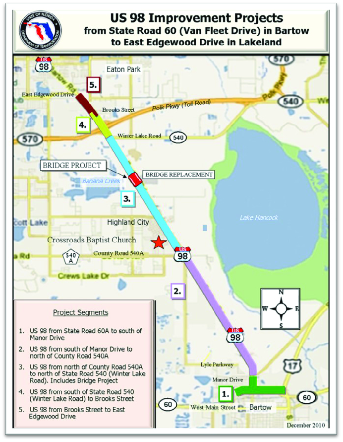 Image Source: US 98 Project Corridor.
Contact
Polk County Transportation Planning Organization
www.polktpo.comAbout the Program
The US 98 corridor in Polk County, FL is a 4-lane divided highway with an abandoned railroad right-of-way adjacent to the east side of the road. In 2001, as development pressures increased, local officials decided they needed to take action to prevent congestion and access issues in a previously undeveloped section of the corridor. The metropolitan planning organization for the region (Polk County Transportation Planning Organization) established a Memorandum of Understanding (MOU) between the Florida Department of Transportation (FDOT), the two cities within the corridor (Bartow and Lakeland), and Polk County. The MOU established the basis for several future roadway improvements along the corridor including widening US 98 to six lanes, provisions for transit service and development of a multi-use recreational trail. A long-range plan for the area (Polk County 2025 Long-Range Transportation Plan) then detailed these improvements. The MOU also outlined state and local objectives that can be met for the roadway through land development and subdivision regulations. It specified several key points: that all government parties would amend their comprehensive plans to include US 98 as a Transportation Corridor; the FDOT would develop a Corridor Access Management Plan (CAMP); all local governments would then amend their land development regulations to implement the CAMP; and finally that all land development and permitting activities that fell within the corridor would be reviewed by a committee made up of representatives from all parties. After collaboration with all parties, experts, and the public, the Corridor Access Management Plan (CAMP) was written and adopted in 2004. The CAMP is particularly useful due to the details of implementation with a series of tables that provide reference for city and county staff as well as recommended policies for local government comprehensive plans. Polk County, the City of Lakeland, and the City of Bartow have all incorporated the CAMP into their planning documents and land development regulations. Polk County has also been able to add corridor projects to their Transportation Improvement Program (TIP). Transportation network improvements throughout the corridor are currently being implemented.
Why it works
The Corridor Access Management Plan instituted for US 98 works particularly well because a significant portion of the corridor is undeveloped, allowing the opportunity for implementation of the CAMP as properties are developed or redeveloped from low traffic generators to high generators. A service road system is also proposed, allowing access to and between businesses for more “local traffic” while the arterial remains less congested for through traffic. The steering committee made up of members of all parties helps decide specific details regarding how a proposed development should comply with the CAMP and helps support staff members who feel political pressure to deviate from the CAMP.
Effective Strategies for Comprehensive Corridor Management