
Preferred Regional Growth Concept

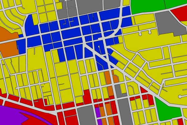
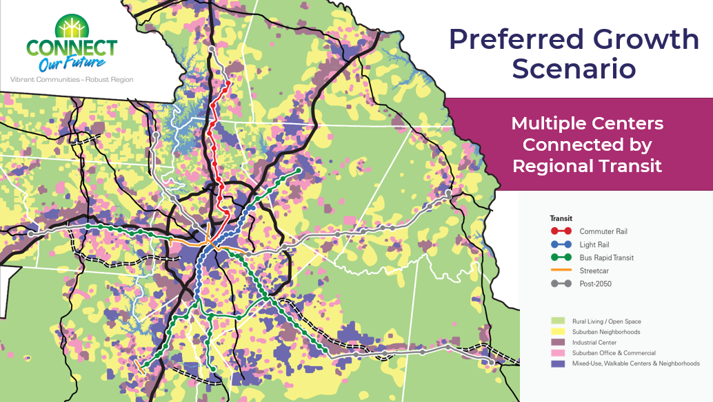
The CONNECT regional growth concept for 2050 is a quilt of preferred growth maps from each of the 14 counties in the greater Charlotte region.

The county-level consortium scenario represents the thoughts and ideas from each of seventeen meetings held with consortium members and/or local government officials in the region. The scenario supports major (re)investment in walkable downtowns, mixed-use activity centers, walkable neighborhoods, and major transit corridors region-wide. More compact development patterns help increase housing choices, travel choices, and open space preservation; create new job centers; and control the cost of providing government facilities and services by concentrating development in smaller service areas. Land outside designated growth areas are preserved as rural or working farms. Download Preferred Regional Growth Concept Map

Skip directly to Key Featured Tools

What does it mean for the CONNECT region?

The preferred regional growth concept is an illustration of one possible land use pattern that can help the CONNECT region achieve community-driven priorities.

CONNECT Priority

How the preferred regional growth concept addresses the priority

Improve Access to Parks and Open Space

Nearly 93,500 more people will be able to live near an existing park of some kind because of the location and intensity of development in the preferred regional growth concept.

Increase Transportation Choices

The increase in new mixed-use, walkable development throughout the CONNECT region equates to an area nearly twice the size of Rock Hill (or 48,166 acres). This type of development generally supports transit, bicycle, and walking trips to meed daily needs.

Support Our Communities

The increased emphasis on compact development in the preferred regional growth concept preserves the character of existing cities and towns, while also preserving the surrounding landscape for rural living, working farms, or open space (nearly 432,000 more acres).

Support Local Farms

The location and intensity of development in the preferred regional growth concept preserves a significant amount of farmland: nearly 78% of all farmland in the CONNECT region (approximately 935,100 acres).

Maximize Return on Public Investment

The type, pattern, and intensity of development in the preferred regional growth concept generates more ad valorem tax revenue per acre, while smaller services areas should reduce government’s cost to serve future growth.

Improve Water Quality

The decrease in impervious surface throughout the CONNECT region equates to an area nearly the size of Rock Hill (or 28,684 acres).

Improve Air Quality

Reducing vehicle trip lengths and providing more travel alternatives to the automobile should reduce CO2 and NOx emissions and improve air quality conditions in the CONNECT region.

Grow Jobs Closer to Home

More opportunities to live and work nearby should shorten trip lengths, reduce commute times, and provide more travel mode options. All of this will give people extra time to do important things in their lives.

Increase Housing Choices

The preferred regional growth concept represents a reasonable number of housing choices to meet future demand, including rural, suburban, walkable suburban, and urban living conditions.

Reduce Commuting Costs

A decrease in the amount of household income spent on transportation means more money available to families for other household needs.

Donald.Kaden

Growth Management and Cooperation

Green Infrastructure

Eric Sehr

Mall-Suburban Corridor Retrofits

Regional Cooperation

Mixed Use Development and Design Guidelines

Capital Improvements Programming

Land Use Modeling

Establishing Appropriate Residential Densities

Transit Readiness Assessment and Primer

Infill Development

Preserving and Building Parks

Transportation Corridor Preservation

Brownfield/Greyfield Redevelopment Toolkit

Educating Officials about Housing Diversity

Agricultural Conservation Easement Programs