Image Source: loonyhiker. Source License: CC BY-NC-ND 2.0. Adaptations: cropped.
Trails and greenways are linear elements of our communities’ green infrastructure network. Trails provide connections that tie communities together, link park and recreation opportunities, and serve as transportation routes. Greenways provide connections that tie natural systems together and conserve important natural resources and character. Although trails and greenways are primarily links in a large system, they can be destinations in their own right.
Why is this important to your community?
Trails and greenways provide much more than a recreational benefit for the occasional jogger and cyclist. Trail networks provide important environmental, economic, social, and health benefits for individuals, communities, and regions as a whole. The presence of trails encourages physical activity, brings communities together around shared assets, increases property values of adjacent properties, and protects important natural resources. Trails also can highlight and celebrate historic or cultural resources, as trails pass through landmarks such as historic battleground sites. Trails also can revitalize obsolete train corridors, as is done with the Rails to Trails Program. Trail and greenway systems, similar to ecosystems and watersheds, are often not specific to individual towns and municipalities, but conceived at the county level or regionally, so it is important to have regional—and sometimes national— (but minimally, county) collaboration when it comes to trail and greenway planning.
Where is it appropriate to use?
What priorities does it address?
What other tools are related?
How does it work?
Trail and greenway planning is most effective when done at the largest scale possible, since the most successful trails and greenways are those that connect the most resources. Greenways may be established by identifying important natural resource corridors and purchasing land or easements, or using overlays to prevent development in sensitive areas (e.g., riparian corridors). At the regional level, trail and greenway planning is often done through councils of governments. However, given the importance of trails and greenways, a variety of different groups may choose to organize around a shared vision for regional greenways. We are fortunate to have the Carolinas Thread Trail (CTT) serving both the North and South Carolina counties of the CONNECT region, which when fully built out, will provide a backbone trail system for the entire region. CTT staff engaged with towns and municipalities in laying out the trail, and continue to work as they are able to help acquire land and build trails that connect to the CTT, so that the trails that are created are not just isolated segments that don’t go anywhere. At their most effective, trails connect not only to a larger trail network but also connect neighborhoods to recreational opportunities, employment locations, and other destinations. Every city and town may have their own unique trail and greenway planning, and have access to a number of tools to promote trails development within their communities, from Rails to Trails to development provisions.
Ready to get started?
Using the Tool
- Create a Greenways and Trails Advisory Committee with community representatives, developers, your local land trust contact, and others, and provide staff support to it through Parks and Recreation and/or the Council of Governments. This body can become your planning and advisory group, to help build up and “sell” your local greenway and trail plans.
- Contact the Carolina Thread Trail for a detailed map of their vision of the Thread Trail for your county, with additional detail for your community, if available.
- Assess your current trail planning for connectivity to the Thread Trail, which allows you to become part of a larger network (providing potential funding, technical assistance, and eco-tourism opportunities).
- Identify ways to boost the connectivity and interest that might draw people to your trail system. This could include any significant historic or natural resources in the community that could become destination points along the trail network, and railroad rights-of-way in the community that could be a potential Rails to Trails connection. Consider also the connectivity of any greenways or trails with shopping, schools, and other destination points—what do you want to connect, and why?
- Consider co-locating trails and greenways in rights-of-way used by other utilities (e.g., natural gas corridors or water/sewer rights of way), that may provide connectivity where it is lacking.
- Discuss how you will link existing and new housing to the trail system. Options may include:
- Developer set-asides for trails or greenways, included in subdivision regulations, or “fees-in-lieu” that provide funding for land purchase
- “Greenway in lieu of sidewalk” alternatives for very suburban developments
- Hazard mitigation funding to convert flood-prone areas to greenways or trails
- Working with property owners of potential conservation areas to obtain easements for trail or greenway space to provide connectivity. Not everyone will be willing to do this, but this approach may help to fill critical gaps in trail connectivity.
- The role that sidewalks will play in connecting neighborhoods to trails. They may be critical in older neighborhoods.
- Vehicle access to trails, because not everyone in the community or county may be able to walk to a trail, and you’ll want multiple access points for trail access, which will involve parking lots or on-street parking.
- Consider also the trail or greenway rules and amenities that will be needed, such as:
- Will you allow motorized vehicles or off-leash pets?
- Will the trails accommodate bicycles as well as walkers? What will that mean in terms of width requirements? This is an important consideration if you want the trail/greenway to also serve as a transportation option for getting to jobs, schools, or shopping.
- What sight distances will you need around trees?
- What protection if any adjacent to water bodies or steep slopes?
- What about water fountains (for people and dogs), “mutt mitt” stations, bathrooms, benches, mile markers, posted rules, and signage?
- Will you include lighting?
- How will the trail/greenway be maintained?
- Will there be special trail or greenway programming, or will that be confined to parks along the way? Note that some greenways get so much general use that “special events” that involve hundreds of additional users may not be feasible!
- Funding options include bonds, grants, developer contributions (see above), community fund-raising, user fees or suggested donations, and CIPs. Identify and investigate funding options that may be viable for each link you need to create, and for any new trails or greenways. Don’t overlook Safe Routes to School for paved greenways that connect with schools that can be used for walking or biking!
- Hold public input sessions—listen to the community for needs, vision, and ideas, and for offers of assistance and problem-solving! The public can become your biggest advocate.
- Update the greenway and trails plan to reflect the advisory body’s findings and deliberations and the public input received. Then take the steps necessary to gain approval for the updated plan, including a proposed funding and implementation strategy and timeline.
- Make sure that public expectations appreciate the fact that greenway and trail development is a long-term process.
- Make sure dedicated staff and volunteers are in place to keep trails and programs in top condition once completed to be a long-standing community and regional resource.
Partners
- Advocacy Groups
- Architects
- Community Development Organizations
- Developers
- Elected Officials
- Engineers
- Health and Wellness Programs
- Health Care Providers
- Housing Authorities
- Landscape Architects, Planners, and Urban Designers
- Land Trust
- MPOs, RPOs, and COGs
Where has it worked?
Carolina Thread Trail - North and South Carolina
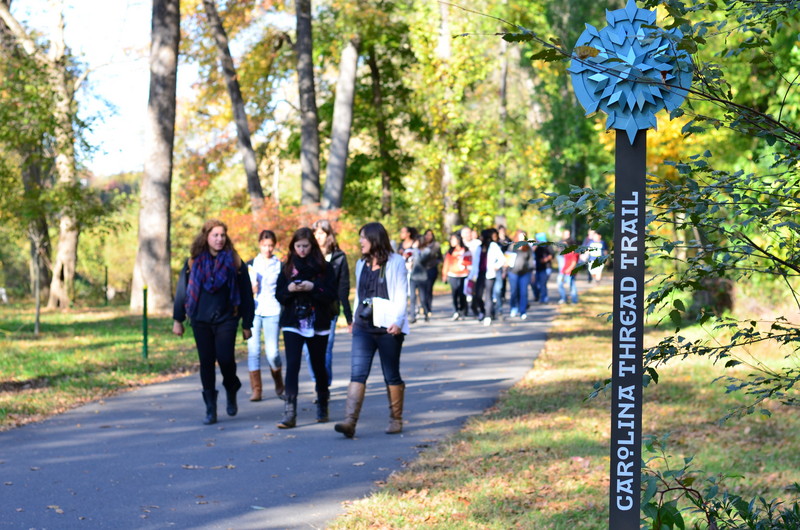 Image Source: Carolina Thread Trail.
Contact
Karl J. Froelich, Director
704.376.2556 ext. 213
karl@carolinathreadtrail.orgAbout the Program
The Carolina Thread Trail is a regional network of greenways, trails, and blueways that spans 15 counties and 2.3 million people in both North and South Carolina, including many in the CONNECT region. Today, the trail consists of 220 miles of publicly-accessible trails, providing an open space connection between people, places, cities, towns, and attractions, while preserving natural areas and creating a place for exploration of nature, culture, science and history. While yet incomplete, the Thread Trail provides an important vision and regional leadership for the completion of a “green interstate” connecting North and South Carolina. The full network is expected to be completed in the next 10 to 20 years.
Why it works
The Carolina Thread Trail has a full time staff and a Regional Advisory Council, consisting of staff members from planning departments, parks and recreation departments, and transportation departments and volunteers from cities and counties in the Trail region. The council provides technical advisement and serves as community liaisons. A Governing Board provides guidance and leads fundraising for the trail. The network benefits from the leadership of the Catawba Lands Conservancy, the lead agency guiding trail development, and the Foundation for the Carolinas leading as the philanthropic partner.
The Trail is financed with both private donations and public funding—a funding model that was developed following two years of planning. Funding is given to local communities as catalytic grants that are then used initial planning, design, land acquisition, and construction of greenways that will eventually link all 15 counties in the region to each other and to other greenway systems outside the region. Funding prioritizes projects that fill connective gaps in the regional trail network. The organization provides technical tools, funding resources, and research for helping communities complete the segments that will eventually complete the network.
Palmetto Trail - South Carolina
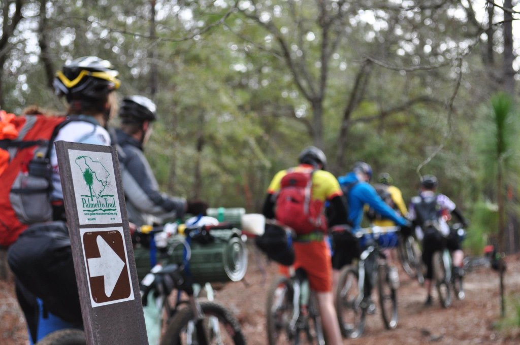 Image Source: VCU Outdoor Adventure Program.
Contact
Natalie Cappuccio Britt, Executive Director
natalie@palmettoconservation.org
803-771-0870About the Program
Conceived in 1994, South Carolina’s Palmetto Trail is the state’s largest bicycle and pedestrian project, extending from the mountains of northwest South Carolina to the intercoastal waterway in the southeastern portion of the state. The Palmetto Trail is a federally-designated Millennium Legacy Trail and is one of only 16 cross-state trails in the country. At present, the Trail is two-thirds complete with 23 segments and more than 350 miles open to the public. Eventually the trail and bike network will be completely connected and include a variety of trail types. Types include mountaintop pathways, maritime, sandhill, and piedmont forests trails, urban bikeways, greenways, and rail-to-trail conversions. Two segments pass through Revolutionary War battlefields. Viewed as a network, or as individual segments, the Palmetto Trail showcases the rich diversity, history, culture and geography of South Carolina.
Why it works
The Palmetto Trail is overseen and managed by the Palmetto Conservation Foundation, the statewide nonprofit whose mission is to conserve and promote the natural and cultural resources of the state. The Foundation’s work includes land trust assistance, the preservation of Revolutionary War battlefields, and developing the greenways of the Palmetto Trail. The foundation has a full staff located in two offices in Columbia and Spartanburg, and works with local municipalities and counties to obtain funding and secure rights-of-way for trail completion. In addition, the Foundation hosts unique programs like selling Trail Shares to allow individuals of all income levels to become partial owners of the trail network, and accomplishes a great amount of trail maintenance through volunteer Trail Work Days.
- Architects