Image Source: The Buzzer. Source License: CC BY-NC-ND 2.0. Adaptations: cropped.
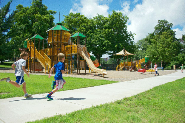
Ensuring that parks and greenways are widely accessible is as important as ensuring a community has an adequate number of parks. This includes access for different age groups, from children to seniors, and by different modes, from those arriving on foot to those driving. Designing parks and open space resources with adequate access and accessibility features, comfort stations, parking lots, sidewalks, and nearby to transit stations is an important component of parks planning and has great impact on public health. The most used parks are those that are well-connected to the communities in which they are located, and/or which are readily accessible to those coming from other areas.
Why is this important to your community?
Access to Park and Open Spaces was identified as one of the top priorities by the residents who participates throughout the CONNECT Our Future regional planning process. The benefits of parks, greenways, recreational facilities, and open spaces are well known—encouraging physical activity, connecting with nature, and supporting mental health, among others. However, not all community members may have equitable access to parks. Residents may be physically close to parks but disconnected for a variety of reasons: insufficient or unclear park entrances, lack of contiguous and safe walking and biking routes, inconvenient locations or frequency of transit systems, insufficient parking, lack of accommodations for those physical disabilities, or safety concerns traveling to parks. Park planners and policy makers should create guidance to ensure that parks are accessible for a variety of users and located in areas that may be accessed safely and through a variety of transportation options such as “complete streets” and transit.
Where is it appropriate to use?
What priorities does it address?
What other tools are related?
- Active Living
- Wayfinding for Trails and Transit (Active Wayfinding)
How does it work?
The physical design of parks is often done on a site by site basis. However, park planners and designers often follow a set of adopted design guidelines, which may be incorporated into a parks and recreation master plan. Design guidelines provide requirements and recommendations for the location of entrances, location and amount of parking, inclusion of sidewalks, and the design of the space in general. Not all communities have a parks and recreation master plan, but guidelines for parking and sidewalks are typically included in the zoning code, which take into consideration ADA requirements.
Park access goes beyond the design of parks themselves. Ensuring that streets have sidewalks and bike lanes to allow for safe access to parks on foot or by bicycle depends on local street design standards. The type of road that connects to a park often determines whether or not it has sidewalks or bike lanes, the speed at which vehicles are travelling, and whether on-street parking is an option (reducing the need for large parking lots within the park). Similarly, transit connections are determined by the area’s transportation authority and its transit service plan. Creating new transit stops depends on the density of development nearby and number of trips that would be served by adding a new stop. Coordinated long-range planning is required to make sure that street standards and transit upgrades are consistent with land use planning and the planning for new and existing parks. Updating the city’s comprehensive plan is the best way to ensure such coordination of policies. Coordinated land use and transportation planning, along with an understanding of park needs and good park design, ensure new parks are designed and existing parks are upgraded to be accessible and well-connected.
Resources
- Accessible Playgrounds
- Guidebook on Local Planning for Healthy Communities. North Carolina Department of Commerce: Division of Community Assistance (East Carolina University). 2013.
- American Planning Association. Healthy Plan Making
- Transit and Trails
- National Recreation and Parks Association standards for parks
Ready to get started?
Using the Tool
- Establish a working group focused on park access, consisting of community leaders and local and regional planners. Establish goals for park access, including entrances, bicycle and pedestrian facilities, parking, transit, and general connectivity to the community. Assess how the various parks are currently accessed in the community and if facilities currently meet these needs. Park accessibility, facilities, and usage typically varies by type of park—whether a local neighborhood park, a community park, a regional park, etc.
- Determine if the municipality, county, or unincorporated area has a parks and recreation master plan. If so, review document to determine if there are policies regarding the connection of parks to the city, county, or regional bicycle and pedestrian facilities. Review the document for guidelines on parking and accessibility requirements. Determine if the plan is consistent with established goals or if the master plan should be reviewed. If no such plan exists, evaluate whether one should be developed.
- Review the current comprehensive plan for policies regarding park access, physical park design, and bicycle and pedestrian connections to parks—and regarding “complete street” and greenway or trail design throughout the city in general. If the plan does not contain such policies, recommend that the plan be updated.
- Review the zoning code to determine parking, sidewalk, and entrance requirements for parks of the various sizes contemplated. Determine if this is consistent with established goals.
- Review any existing pedestrian or bicycle master plan for policies regarding connections to parks. If such policies exist, implement suggested actions. If not, suggest that this plan be revised to be consistent with goals.
- Review street standards for new streets to determine if bicycle and pedestrian facilities are included for those streets that provide access to parks. If not, suggest that these be revised/ amended to include strategies for “complete streets.”
- Review current transit plans of the transportation authority. Determine if there are policies in place to encourage accessibility of parks via transit. Work with transportation planners to implement or create such a policy if none exists.
- Continue to monitor park access and use, so that challenges to access or connectivity can be addressed as they occur.
Partners
- Advocacy Groups
- Colleges and Universities
- Community Development Organizations
- Health and Wellness Programs
- Landscape Architects, Planners, and Urban Designers
Where has it worked?
Legacy 2030 Comprehensive Plan - Winston-Salem / Forsyth County, NC
About the Program
The City of Winston-Salem/ Forsyth County completed an updated comprehensive plan—Legacy 2030—in 2013 and won the 2014 Daniel Burnham Award for a Comprehensive Plan from the American Planning Association (APA). The plan dedicates a full chapter to planning for healthy communities entitled Healthy, Complete, and Equitable Communities. This plan element includes adequate access to parks and open space as a key element of achieving healthy communities. The plan also includes recommendations for providing safe sidewalks, greenways, and trails to promote alternative modes of transportation.
Why it works
Legacy 2030 includes specific actions about park access. This includes reviewing connectivity issues that may exist in connecting homes to schools and parks (8.4.2), ensuring safe access for children (8.4.3), and senior access to public facilities (8.4.7). Legacy 2030 ties directly to the City-County Parks and Open Space Plan, which offers guidelines and locations for where and how many parks need to be built. Currently, the plan calls for the building of new facilities in areas where parks are lacking. As master plans for new and expanded park sites are completed, following these recommendations and the policies of the Parks and Open Space Plan, they will also look to the recommendations of Legacy 2030, which includes policies for park access. These include: “Routes to Parks and Recreation,” which considers the availability of public transportation and pedestrian and bicycle routes to existing and parks and recreational facilities in designing new parks; “Safe Park Environment,” which ensures that the areas surrounding and within parks are safe, and “Safe Access to Parks,” which promotes safe access to parks for children. Through the application of these policies in future land use decisions and park planning, the Winston-Salem/ Forsyth County officials will ensure that park accessibility concerns as voiced through the community are met and realized.
http://www.cityofws.org/departments/planning/legacy/legacy-2030
Walk Bike Columbia - Columbia, SC
 Image Source: City of Columbia, SC.
Contact
Lucinda Statler, Project Manager
lsstatler@columbiasc.netAbout the Program
Walk Bike Columbia is an ongoing plan in Columbia, South Carolina, to improve the multi-modal network and advance the culture of bicycling, walking, and transit in the city. The project is sponsored by the Central Midlands Council of Government and the City of Columbia. The city has recently increased its level of programming for bicycles, pedestrians, and transit, and has established a Bicycle Pedestrian Advisory Council (BPAC). Columbia recognizes that its streets are largely designed for cars, not people, and that the city is difficult to navigate by bike, on foot, or by transit. City leaders have recognized that the quality of life of the community will be enhanced by paying closer attention to these networks and therefore recently kicked off a plan to respond to this need. The planning process kicked off in May 2014, aided by funding from the Federal Transit Administration (FTA) and local partners, and will extend through April 2015. The project will recommend a network of complete streets for the City of Columbia, as well as biking- and walking- related programs and policies. Walk Bike Columbia will set the stage for national designation as a Bicycle and Walking Friendly Community and advance bicycle and pedestrian planning in the State of South Carolina.
Why it works
While the planning process has just begun, important steps have already been taken to evaluate the current programs in place in the City of Columbia, examine existing facilities, gauge stakeholder and community input, and determine the role of bicycle and pedestrian access throughout the city’s current policies. The recommendations of Walk Bike Columbia will then be used to guide all future planning and development as it pertains to bicycle and pedestrian access.
The Walk Bike Columbia team created a matrix of existing planning documents and how they address bike and pedestrian policies. This included the City of Columbia Parks and Recreation Master Plan, the five-year vision for parks and recreational facilities for the city. The plan called for a greater focus on system-wide park linkages through greenways and waterway features, including trail access. Any subsequent update to the plan would look to the recommendations of Walk Bike Columbia to include more detailed policies on park access via walking and biking and designs to accommodate enhanced bicycle parking, sidewalk connections, etc. The statewide multimodal transportation plan, Charting a Course to 2040, was recently completed. That plan’s guidance for improving bicycle and pedestrian connections throughout the state will also be folded into future transportation and park designs in the city.
- Colleges and Universities
- Wayfinding for Trails and Transit (Active Wayfinding)